Have You Heard About The Anti Tank Trap at Sefter Road?
Residents who came to the meeting at Church Farm probably heard references to the above by various people as it is believed in some quarters including Arun District Council, that this in some way could be "resurrected" to partially solve some of the flooding issues in the area. It is therefore relevant and of some interest to learn the history of this ditch. Linked to this ditch was another piece of history in the shape of a Pill Box situated in the field behind the Scout Hut at Sefter Road. This particular one obviously tied in with the Anti Tank Ditch and we are indebted to Gill and Albert Homer, as well as Dick Clinch and Ron Lane for the following information.
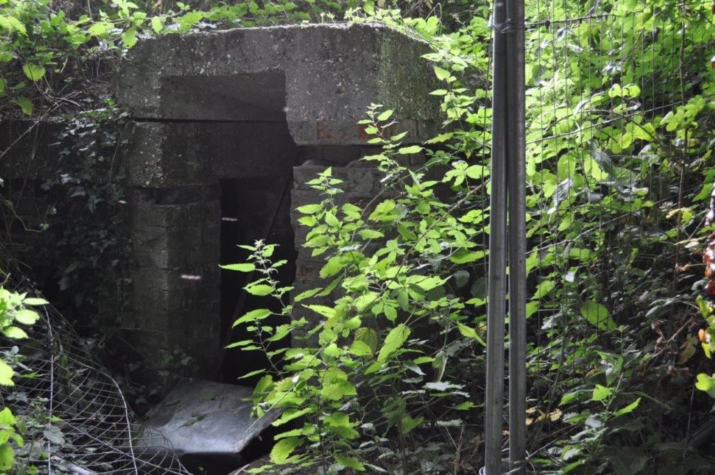
" After the tragedy at Dunkirk, it appeared that a German invasion of Britain was imminent and preparations were made to resist or repel the enemy should they gain a foothold on our shores. Part of the plan was to build miniature forts or "pillboxes" in strategic places to frustrate the enemy advance. They were built mainly of concrete but some bricks were used in "curtain walls", protecting doorways because of a shortage of building materials at the time. This pillbox, about 100 yards North of the junction of Hook Lane and Sefter Road was built about 1940, had apertures for two or three machine guns and its field of fire covered a large part of Pagham Harbour. It was not intended to protect the Advanced Landing Ground in Chalcraft Lane, as this was built some four years later, but would have played a part in the airfield's defences later in the War.
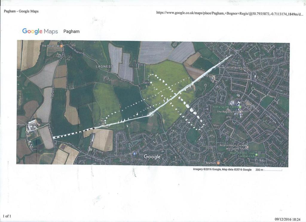
Another defensive measure put in place at the same time as the pillbox was the anti-tank ditch. About 2.4 metres deep a ditch was dug from North of Chalcraft Lane, through the Copthorne Caravan Park site, running along the Northern edge of the Taylor Wimpey site and then near Sefter School. Another local resident Dick Clinch also added his memories and detail on this. " The western end was just North of the junction of Pagham Road and Sefter Road and on the other side of Pagham road there was a drainage ditch which ran south for a short distance before turning West and presumably drained into Pagham Rife. The Eastern end stopped just short of the Royal Oak (Pink Pub) in North Bersted. It was probably slightly curved along its length rather than turning sharply as shown on the attached maps.(( Albert Homer interjects here and states that he (Dick) may have been unaware that apparently it went all the way to the Aldingbourne Rife as it says in Sylvia Endecot's book "It Started with a Map!". She also says something like "it snaked", so it wasn't anything like the straight lines I drew on the map! )) It was dug by a dragline with a huge bucket Dick remembers, and would have been done in late 1940 or early 1941 when preparations were underway to repel what was thought to be an imminent German invasion. In 1944 when the Advanced Landing Ground at Chalcraft Lane was constructed some parts of it would have been filled in. In 1947 when the Urban District Council filled in the rest of the ditch the section from Sefter Road to Robin Dean's place (the last house in Sefter Road according to Dick) was used to lay in a 39 inch pipe . Dick and a friend actually walked along the length of it inside this pipe.."
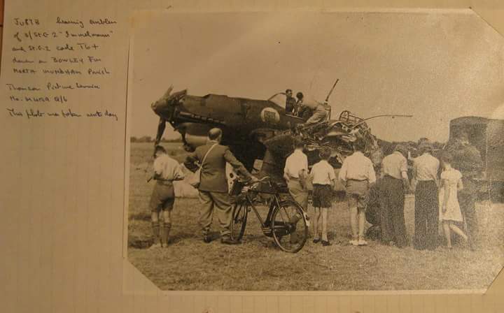
Ron Lane also commented about a bomber brought down after a raid on Tangmere. Ron remembers that an anti-aircraft gun was situated in Hook Lane, near the junction with Sefter Road and that he witnessed the pom-pom guns in action against enemy fighters and bomber's, and that one was brought down about 15 yards into the field near the battery. The pilot was killed in the crash. It crashed at Bowley Farm , which is just outside Pagham Parish (right on the boundary actually) and shows local people from Aldwick and Pagham inspecting the wreckage.
Albert also has added the following information about this ......
"The plane that Ron Lane says crashed in the field 15 yards in from Hook Lane was actually a fighter, not a bomber, although I don't know the make (German). The plane that crash landed on Bowley Farm at about 1305 hours on the 16th of August 1940 was a Stuka JU87 bomber. It had just taken part in the devastating raid on Tangmere Airfield and was brought down by Flying Officer Carl Raymond Davis from 601 Squadron. One of the two man crew of the Stuka died that day and the other the next day. F/O Davis was an American , living in London who joined the Royal Auxilliary Air Force and after joining 601 Squadron was credited with nine enemy kills and was awarded the Distinguished Flying Cross. Tragically he was shot down and killed 6/9/1940, aged 29 years and is buried at St Mary's churchyard, Storrington, West Sussex.
The name of the road near the ALG is Chalcraft Lane (not Chalcroft as it is often mis-named!) "
The following picture gallery shows 3 photo's, first .... the Pillbox that has been talked about, secondly ... a superimposed image of the ALG (Advanced Landing Ground) where the Murrells Farm site might be by Chalcroft Lane. The image of the airfield is shown, as well as THAT ditch which might be utilised if you believe various sources to drain excess surface water into the Rife and thus to Pagham Harbour. The final photo is of the Stuka bomber already mentioned as shot down, with various onlookers, a photo that is extremely poignant to Gill Homer as her Dad and brother are two of the onlookers with their backs to the camera.
This area of the website will be elaborated on as we get more detailed information the Anti Tank Ditch etc., particurly the maps shown but in more exacting detail ... Watch this space !!